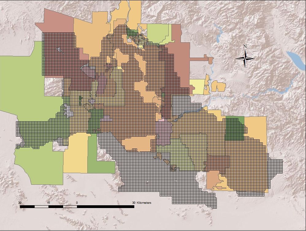
Water Service Providers
We model 33 Water Providers in the Phoenix Metropolitan Area. These water utilities cover approximately 95% of the people in the Phoenix Active Management Area (As defined by the Arizona Department of Water Resources: A geographic area that has been designated pursuant to A.R.S.§ 45-411 as requiring active management of groundwater).
Arizona State University,
Decision Center for a Desert City, The Brickyard Orchid House, 21 East 6th Street, Tempe, AZ 85287-8209
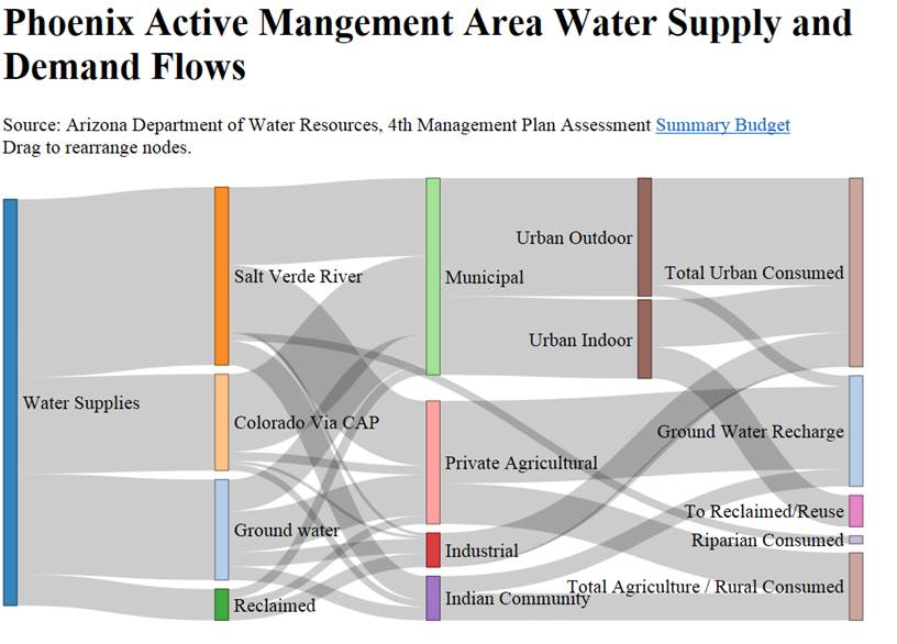
Water Supply and Demand
Water supply SandKey Flow Chart.
Arizona State University,
Decision Center for a Desert City, The Brickyard Orchid House, 21 East 6th Street, Tempe, AZ 85287-8209
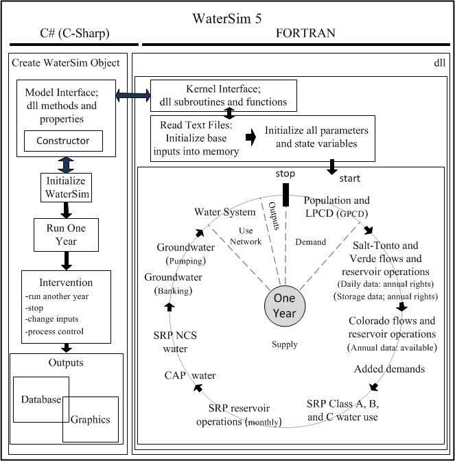
Model Structure
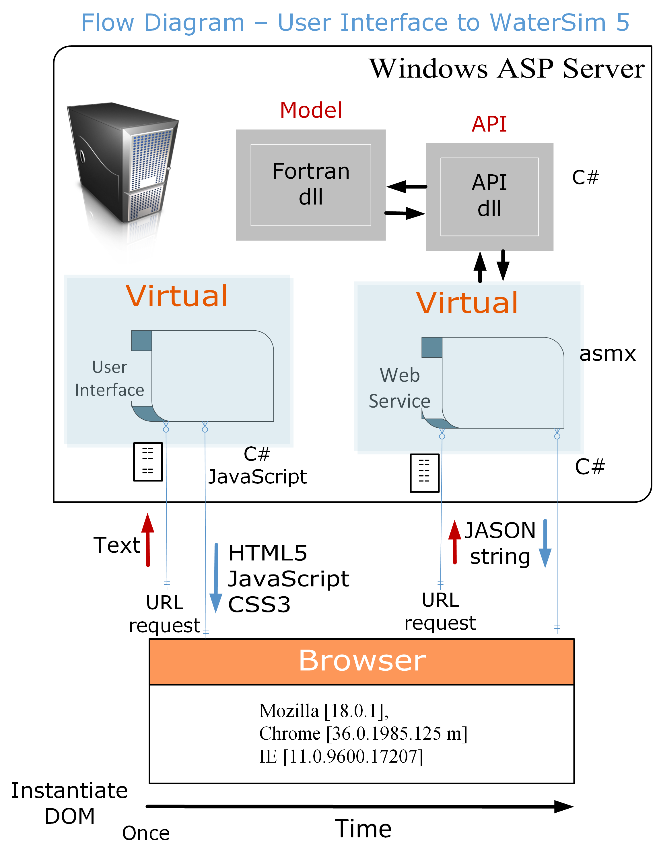
The WaterSim framework consists of a FORTRAN module (dll) linked to a C-Sharp (C#) "wrapper" dislayed in the image below. The C# libraries control the model, setting the user inputs and extracting the model outputs for data storage or for graphing. The individual modules of the FORTRAN model are designated in the run sequence.
WaterSim uses water demand to drive the water supply pathways (see image below). The various water supply sources are depicted in the model diagram.
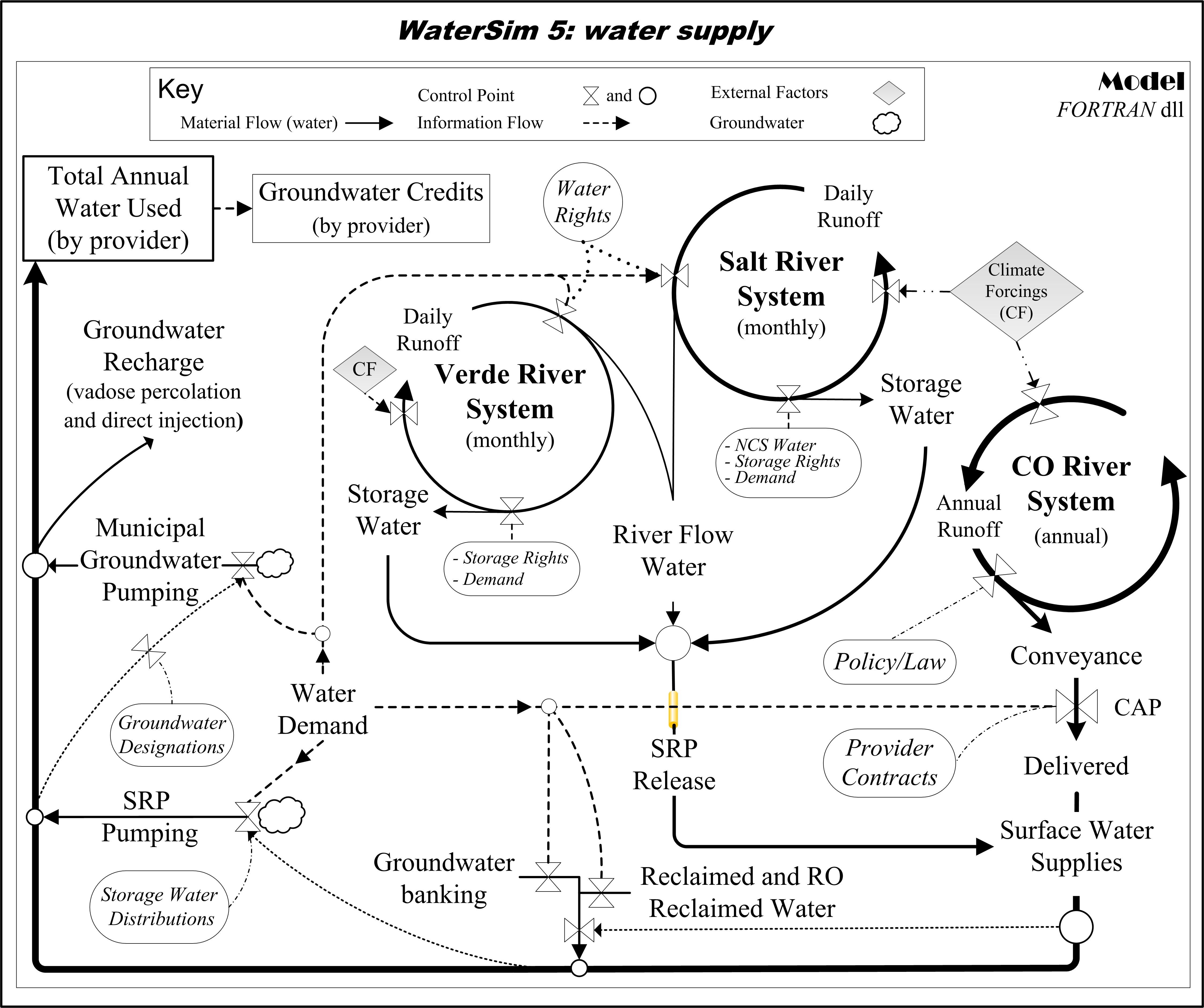
City-model water use network.

Browser, web service, API, and model configuration.
Arizona State University,
Decision Center for a Desert City, The Brickyard Orchid House, 21 East 6th Street, Tempe, AZ 85287-8209
Model Verification and Validation
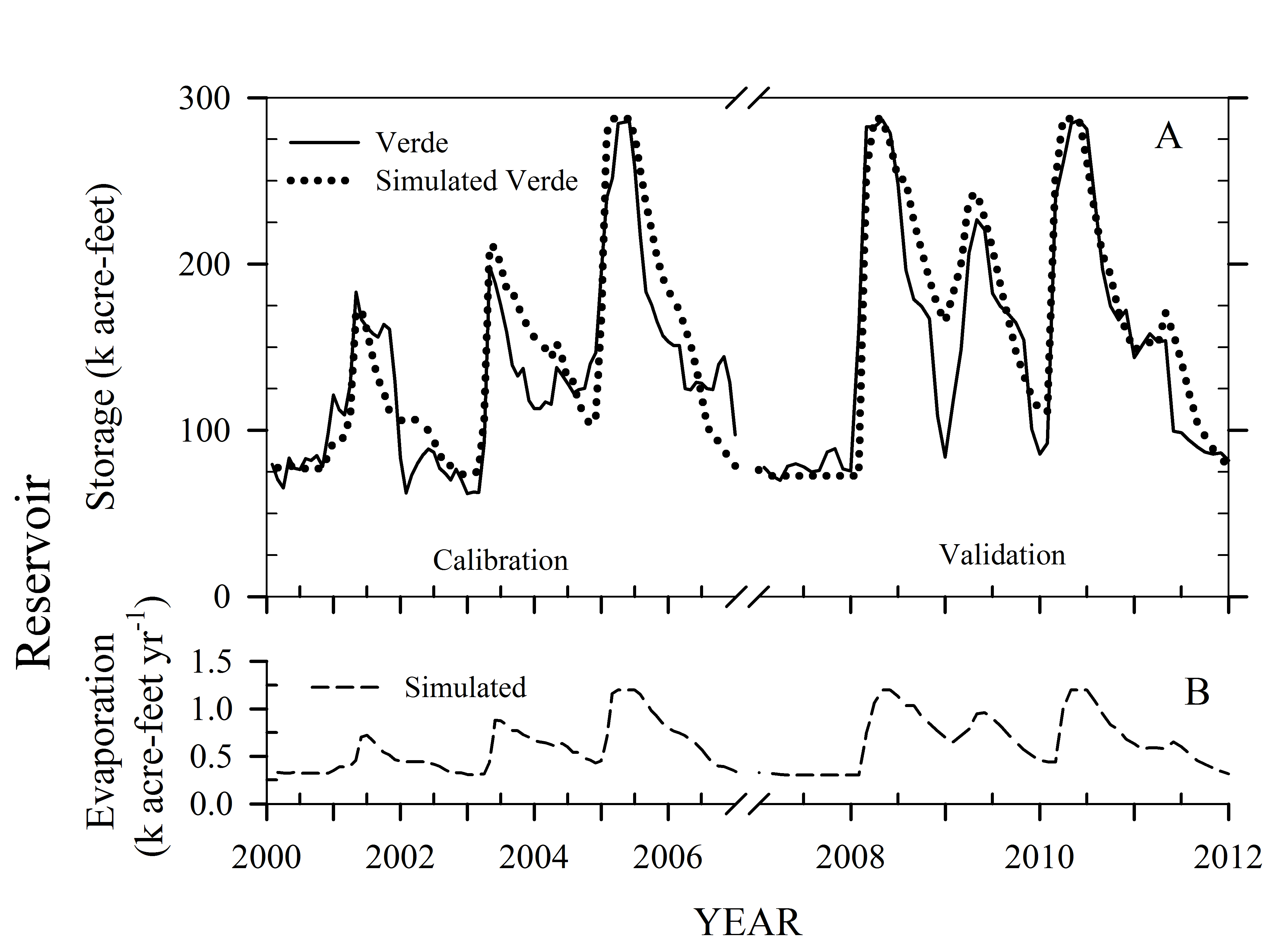
The figure below depicts results from the parameterization and validaiton of the reservoir storage dynamics (A) on the Verde River System and simulated evaporation (B). Here the outputs reflect the total volume in the two Verde reservoirs; Horseshoe and Bartlett (2000 through 2012).
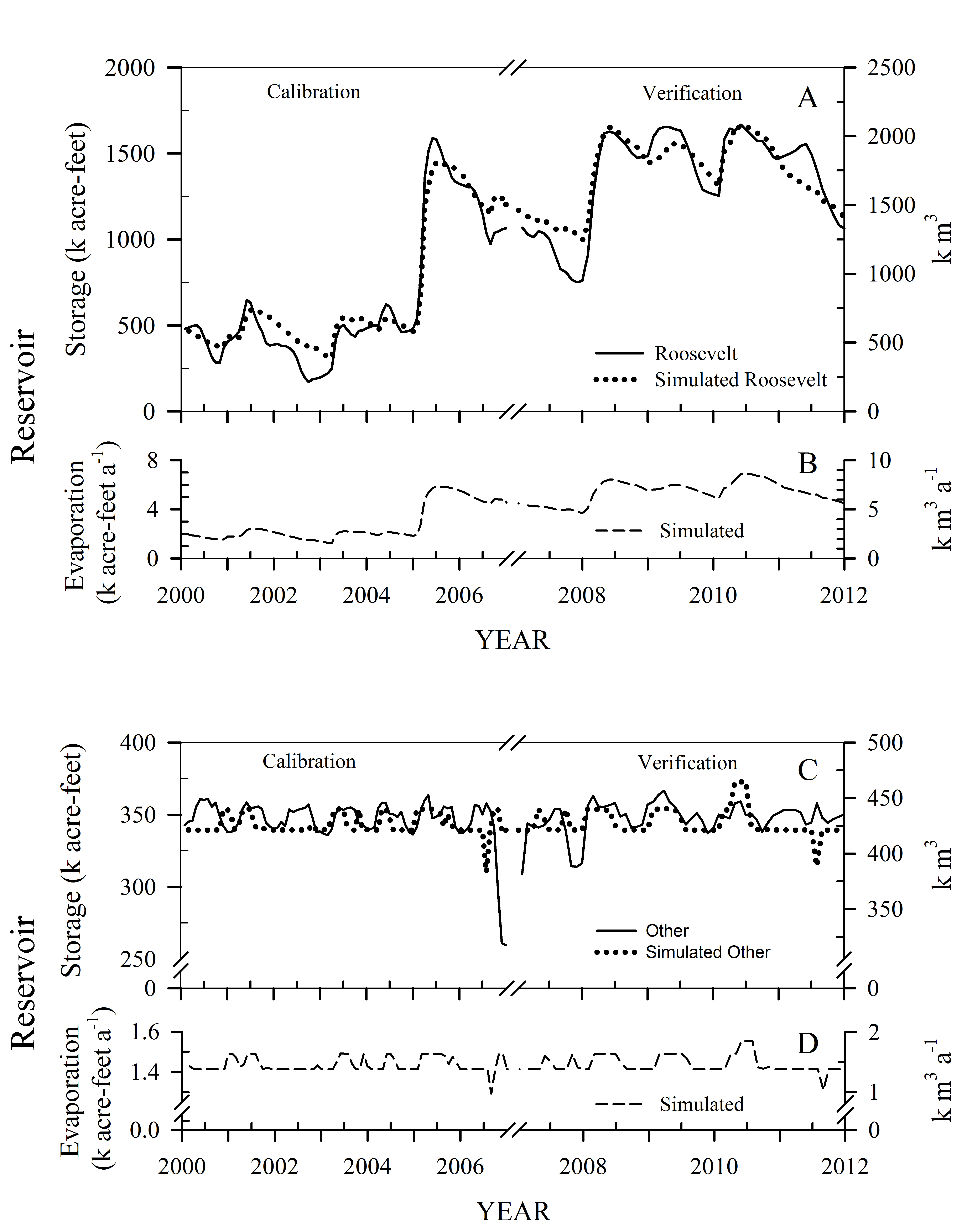
The figure shown below depicts water storage (A) and evaporation (B) on Lake Roosevelt, the largest of the reservoirs on the Salt-Tonto River System and the other three reservoirs combined (C) and (D).
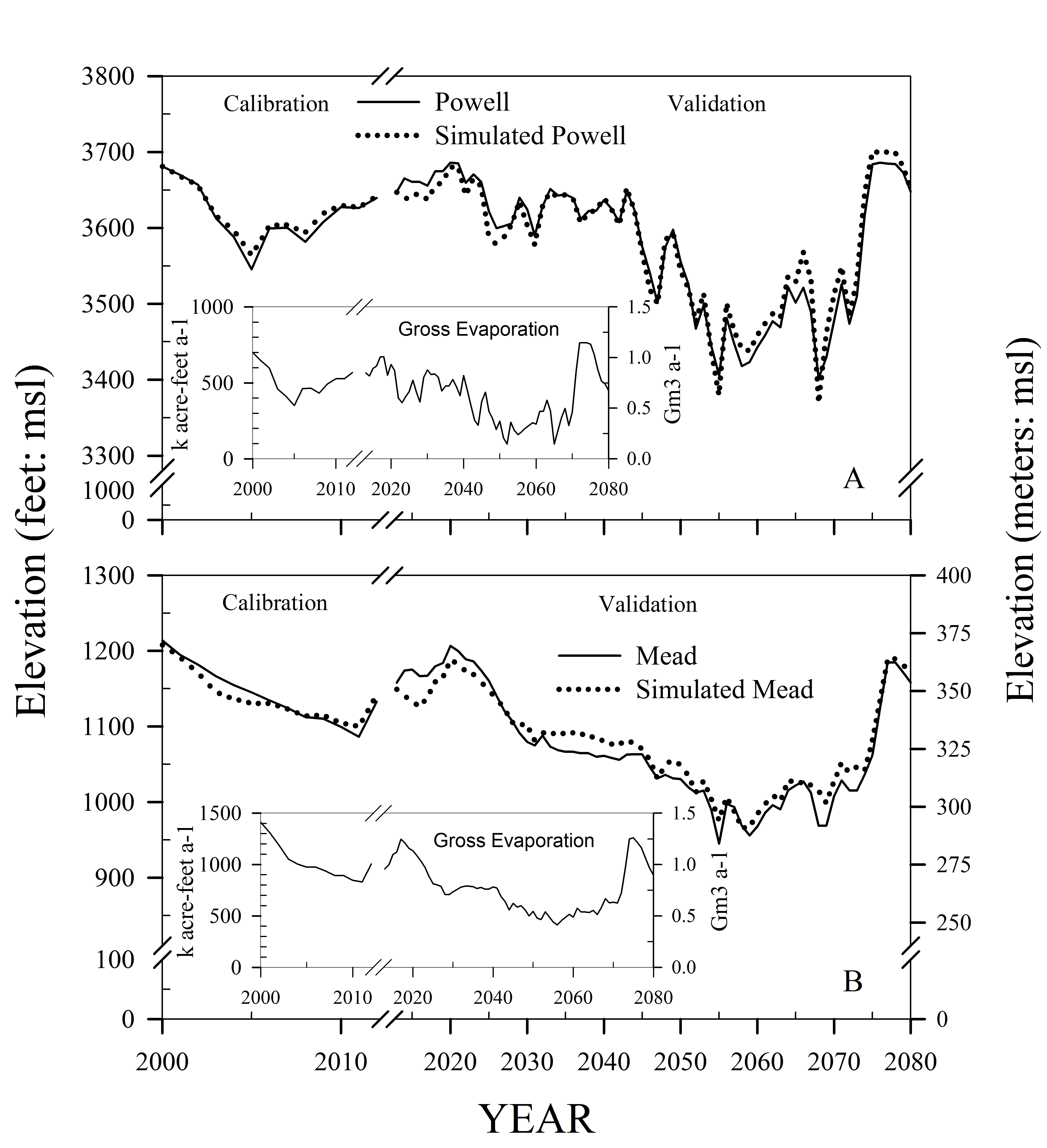
The figure shown below depicts lake level elevation and evaporation (insert) on Lake Powell (A) and Lake Mead (B). Simulations from WaterSim were compared against simulations from the Bureau of Reclamation CRSS simulation model (provided by Don Gross- ADWR).
Arizona State University,
Decision Center for a Desert City, The Brickyard Orchid House, 21 East 6th Street, Tempe, AZ 85287-8209
Model Outputs
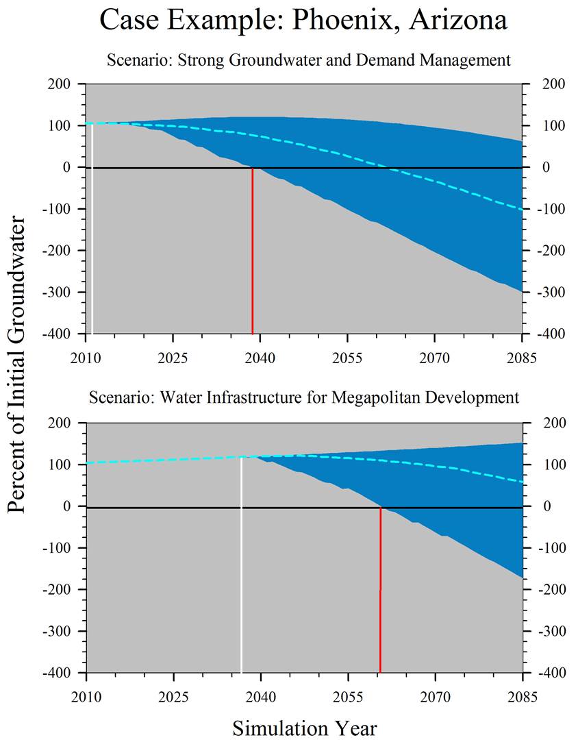
With WaterSim 5 we can examine the regional response in the aquifer over time, groundwater pumping, and groundwater credits under various water policy management options. What follows is an example of 11,500 scenarios from Sampson et al. (in press).
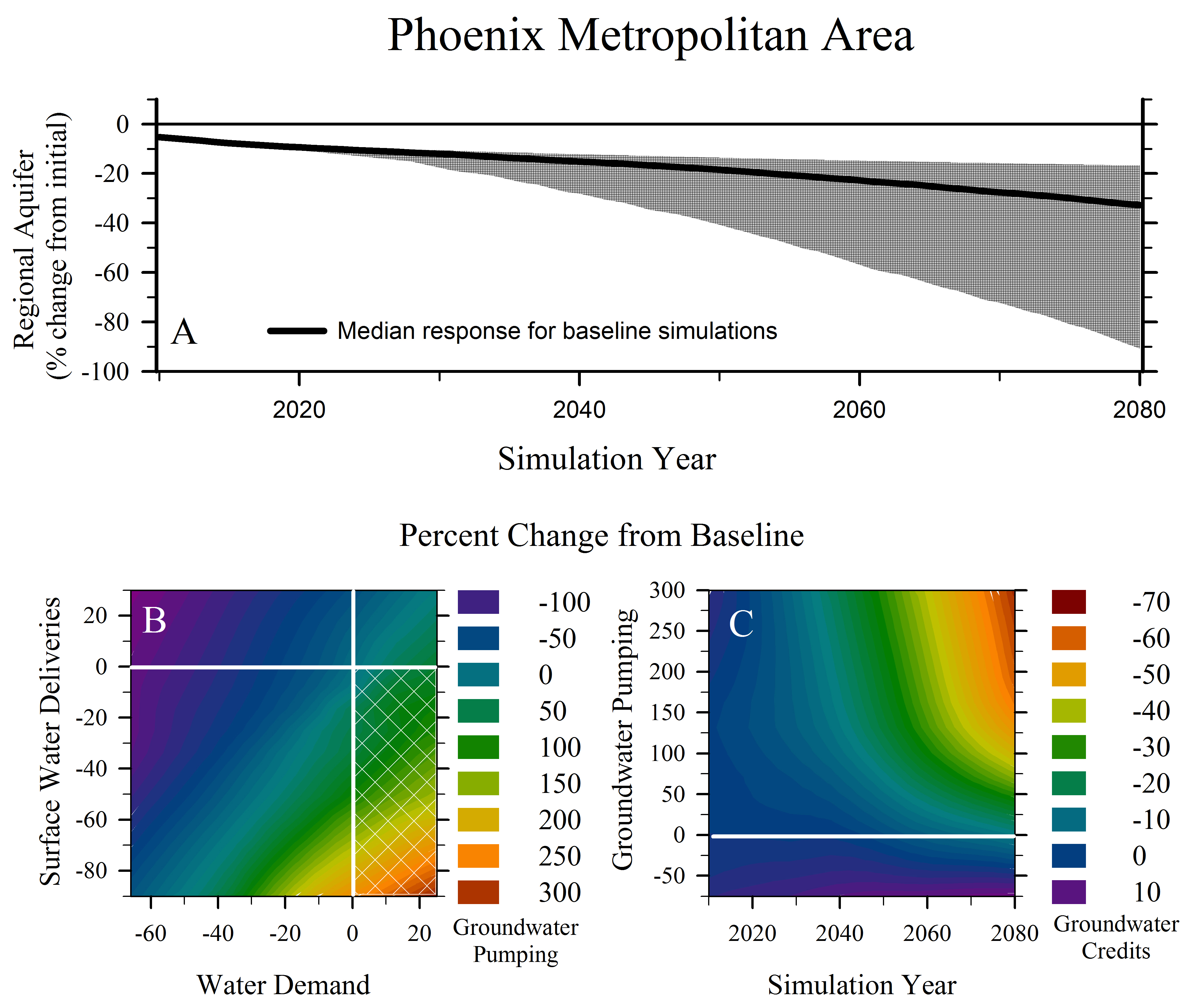
An example of hundreds of scenarios and thousands of simulations looking at
a response envelope and tipping points.
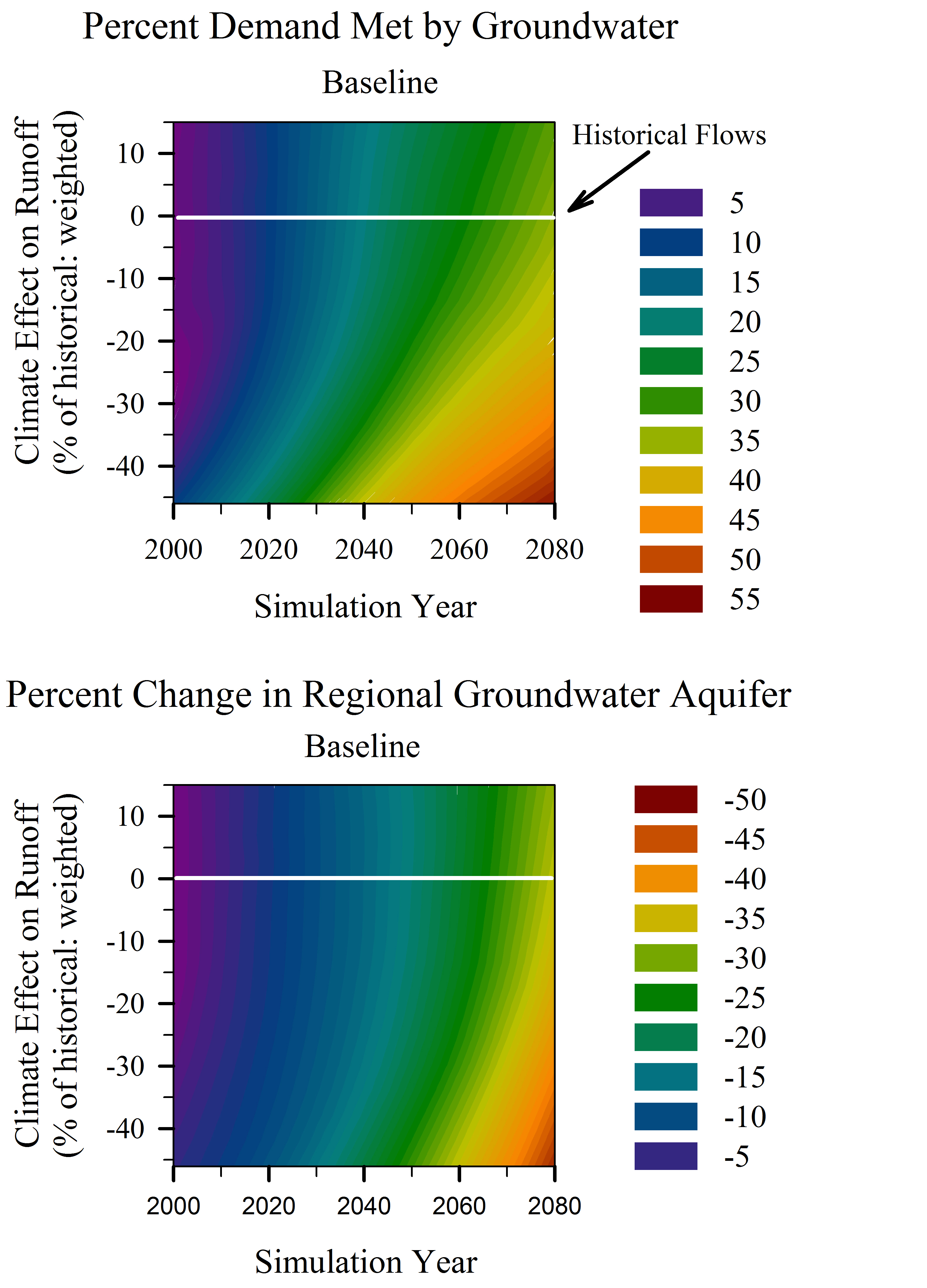
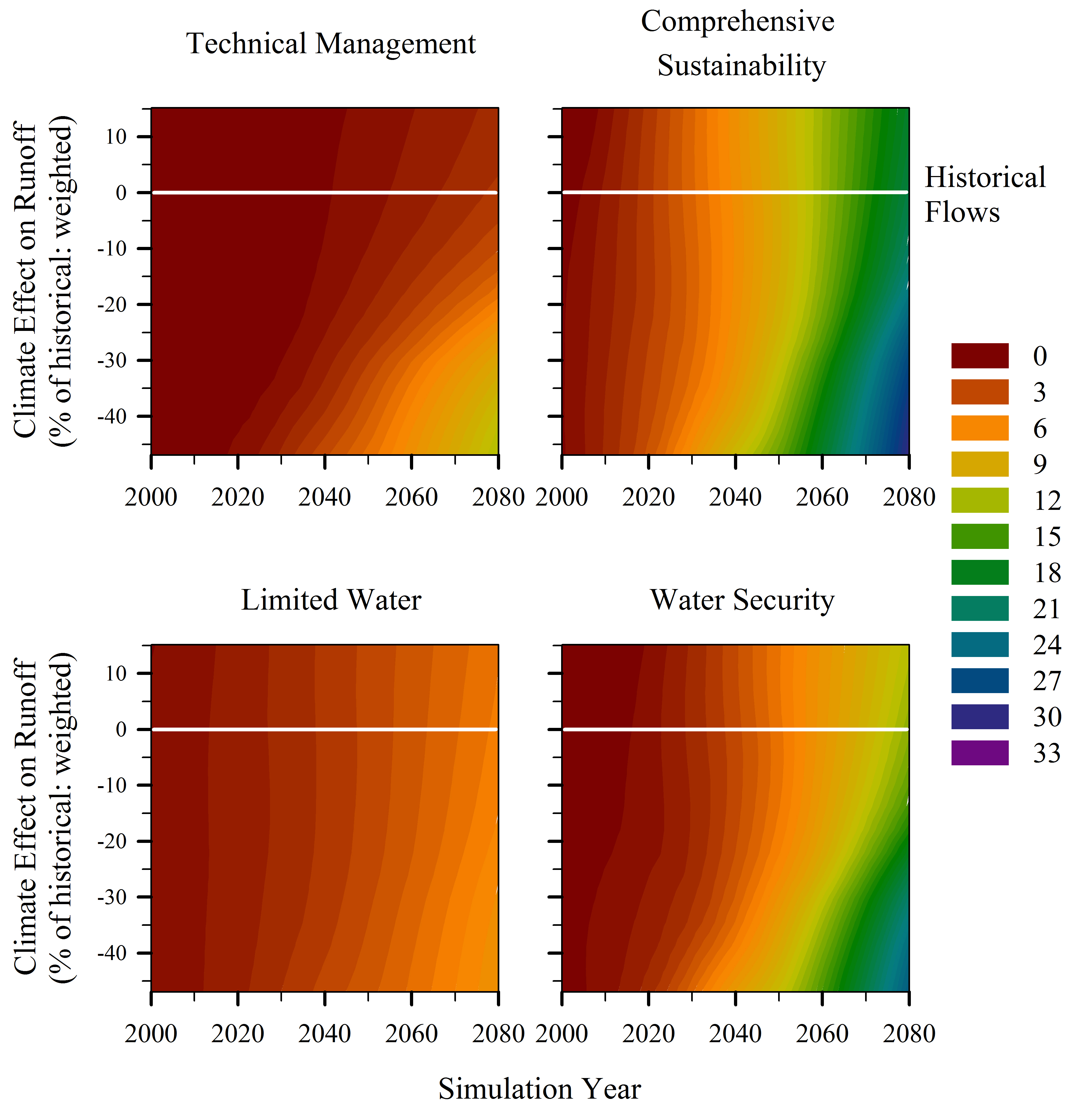
An example of hundreds of scenarios from WithycombeKeeler et al.(2015).
Arizona State University,
Decision Center for a Desert City, The Brickyard Orchid House, 21 East 6th Street, Tempe, AZ 85287-8209
Publications
Published:
Quay, R. 2015. Planning for demand uncertainty in integrated water resource planning. Journal – American Water Works Association (JAWWA) 107(2):32-41.
Withycombe Keeler, L.,A. Wiek, D.D. White and D.A. Sampson. 2015. Linking stakeholder survey, scenario analysis, and simulation modeling to explore the long-term impacts of regional water governance regimes. Environmental Science and Policy 48:237-249.
Gober, P., D.D. White, R. Quay, D.A. Sampson, and C.W. Kirkwood. 2014. Socio-hydrology modelling for an uncertain future, with examples from the USA and Canada. In Model Fusion: Integrating Environmental Models to Solve Real World Problems. Geological Society of London, Special Publications Series.
White, D.D. 2013. Framing water sustainability in an environmental decision support system. Society & Natural Resources 26(11):1365-1373. DOI: 10.1080/08941920.2013.788401.
Murray, A.T., P.D. Padegimas, P. Gober, L. Anselin, R.J. Sergio, D.A. Sampson. 2012. Spatial optimization models for water supply allocation. Water Resources Management 26(8): 2243-2257. DPI: 10.1007/s11269-012-0013-5.
Gober, P., E.A. Wentz, T. Lant, M.K. Tschudi, and C.W. Kirkwood. 2011. WaterSim: A simulation model for urban water planning in Phoenix, Arizona, USA. Environment and Planning B 38(2):197-215. DOI: 10.1068/b36075.
Sampson, D.A., V. Escobar, M.K. Tschudi, T. Lant and P. Gober. 2011. A provider-based water planning and management model—WaterSim 4.0—for the Phoenix Metropolitan Area. Journal of Environmental Management 92: 2596-2610.
Gober, P., and C.W. Kirkwood. 2010. Vulnerability assessment of climate-induced water shortage in Phoenix. Proceedings of the National Academy of Sciences USA 107(50):21295-21299.
In Press:
White, D.D., A.Y. Wutich, K.L. Larson, and T. Lant. In press. Water management decision makers’ evaluations of uncertainty in a decision support system: The case of WaterSim in the Decision Theater. Journal of Environmental Planning and Management. DOI:10.1080/ 09640568.2013.875892.
Arizona State University,
Decision Center for a Desert City, The Brickyard Orchid House, 21 East 6th Street, Tempe, AZ 85287-8209